Barry sez,
Google Maps keeps evolving, expanding the ability to drill down into granular detail. The latest updated trick? Mapping foreclosures for sale. This great and terrible Google trick has been around at least since 2008 -- but it seems to have become much more robust earlier this year:Google Map Foreclosure Tricks (Thanks, Barry!)1. Punch any US address into Google Maps.
2. Your options are Earth, Satellite, Map, Traffic and . . . More. (Select "More")
3. The drop down menu gives you a check box option for "Real Estate."
4. The left column will give you several options (You may have to select "Show Options")
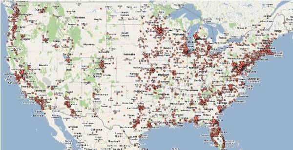
5. Check the box marked "Foreclosure."I wanted to demonstrate the full extent of Foreclosures in the US, so after setting GMaps on foreclosure listings, I slowly zoomed out of the map. Voila! Most foreclosures that are for sale in the USA are now showing on your screen. (Note: This map does not reveal any of the millions of REOs that have already been sold by the banks that hold them).
Â
- Florida foreclosure mill owner who chucked out 70000 families in ...
- Foreclosure King Defaulting on His Foreclosure Mill HQ - Boing Boing
- Bank of America forecloses on a man who has no mortgage - Boing Boing
- Michigan GOP attacks right-to-vote for the recently foreclosed ...
- Banks refuse to take title on repossessed crappy houses - Boing Boing
- What happens to junk left behind in foreclosed homes? - Boing Boing
- Todd Lappin's photodiary of Modesto, CA: Foreclosureville - Boing ...


